HazardsRisks to Population
Recent eruption at Galeras volcano have been characterized by Vulcanian style eruptions, which often include pyroclastic flows, sulfur dioxide degassing, and ash plumes. Because of the close proximity of the town of Pasto, with a population near 400,000, a large scale eruption could be catastrophic. Fortunately, the most recent edifice collapse breached the western wall of the caldera and now directs many of the flows and other volcanic products away from the town of Pasto, which is to the east of the summit. However in the case of a major eruption (VEI 3-4) and a column collapse-style pyroclastic flow, many thousands of people would need to be evacuated. Fallout and lahars are also issues that the residents of the surrounding villages and cities face. Due to the steep river drainages coming off of the volcano, these are important hazards to keep in mind. Aviation agencies must also be warned of ash plumes, because of the extreme damage that may be cause to a plane if it flies through a plume. The series of maps to the right published by Ingeominas illustrates the very real threat of pyroclastic flows and fallout (Ingeominas, N.D.). Current Monitoring Activities Ingeominas in Pasto, Colombia employs a number of monitoring tools. These tools include a visual observatory in Pasto, webcams to monitor geomorphic activities, a seismic network, deformation monitoring network, vector red leveling, Radon-222 soil emission monitoring, sulfur dioxide emission and sludge flow monitoring, electromagnetic field network, measurement of spontaneous electrical potential, air monitoring of thermal and geomorphic changes, and satellite monitoring (NOAA, OMI) of volcanic gas emissions (Ingeominas, N.D.). Link to english translation of current monitoring network Link to digital seismogram Analysis of Hazards (NVEWS Ranking)
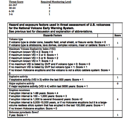
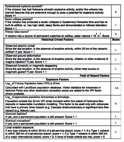
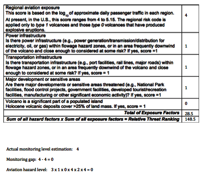
Figure 19: Chart showing the system for ranking a volcano with USGS' VNEWS ranking system. According to this ranking system, Galeras is at the highest monitoring level. Template courtesy of USGS.
|
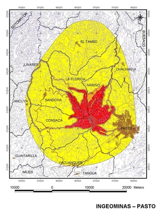
Figure 16: This map is the third published version of the hazard map for Galeras. It is separated by high, medium, and low danger zones, red being the highest. Retrieved from Ingeominas (N.D.).
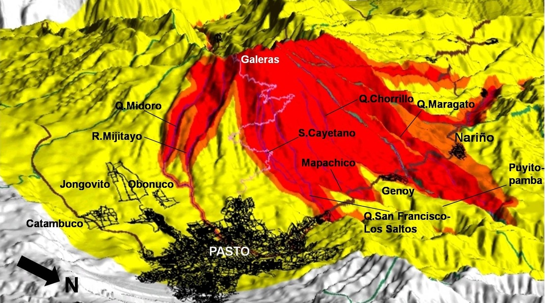
Figure 17: Three-dimensional view of hazard map looking from the east. Note the high-risk zones that run through the middle of Pasto. retrieved from Ingeominas (N.D.).
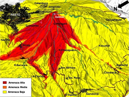
Figure 18: Three-dimensional view of Galeras hazard map, viewed from the northwest. Retrieved from Ingeominas (N.D).
Proposal for Risk Minimization
To effectively reduce the risk of the volcanic hazard Galeras poses to the surrounding communities, some important steps should be taken. First, the hazards maps above, should be distributed to the public and explained at government meetings and in schools. Making people aware of the threat of the volcano is a powerful tool in the reduction of volcanic hazards. The next step needed is an educational outreach program geared towards the smaller villages surrounding the summit. It is these small villages that do not understand the need for evacuations because they have lived through many periods of activity that have not produced eruptions. If they become aware of the potential for a serious eruption and loss of life , then they may consider evacuating their villages. The overall key in a successful risk mitigation program is to distribute the Galeras hazard maps and bring about public awareness about the dangers of the volcano. Only then will an efficient evacuation procedure be able to be implemented. 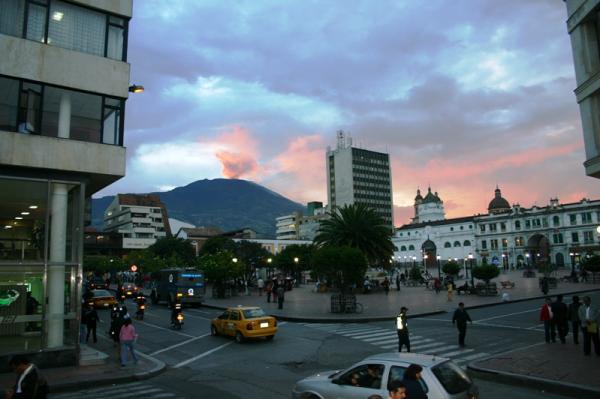
Figure 20: Image of Galeras volcano emitting steam, visible from a downtown street in Pasto, Colombia. This picture shows the close proximity of Pasto to the volcano and sheds light on the real danger posed by Galeras. Retrieved from http://www.environmentalgraffit i.com/news-cities-lying-shadow-volcanoes?image=11
|
| Galeras - Colombia's Most Active Volcano |
|
